THE EASTERN LOOP
The Eastern Loop is the final leg of The Lancashire Way – a long distance walk of almost 400 miles covering the beautiful county of Lancashire. It has been created to ensure that the Lancashire Way is complete and misses no part of Lancashire, which is worthy of a walk. A summary of the walk can be found in the table below. It is 99 miles long, is divided into 18 individual stages, with the longest being just under 10 miles. This will hopefully enable you to organise any walk to suit your pace. The end of each stage are generally easily accessible places and sometimes with public transport allowing the walk to be done in a series of day walks. I will put together suggestions as to how this might achieved as soon as I can. The total ascent of the route is just over 14,000ft so it is actually the “biggest” of the four loops in that respect.
I also need to confess that the route is not entirely original. The Boroughs of Pendle and Rossendale have supported their own long distance walks in the form of the Pendle Way and the Rossendale Way. They keep these well established walks generally well maintained and signposted. So rather than re-invent the wheel, I used these but have deviated from time to time. Their routes are constrained to some extent by the limit of their borough boundaries. Also from time to time I feel there is a slightly better route. Of course, these two routes need joining and to some extent the Burnley Way helped in this respect. Finally, the route also uses parts of the Pennine Bridleway and the Bronte Way.
It differs from the other Loops in that it is not covered by OS Maps, which are expensive. I suggest that you complete at least one of the other Loops – probably the Central or Northern Loops first. If you feel that the Eastern Loop is for you can download a GPX file to cover the full 90 plus miles within the MAPS menu. You may need a device to read this or as I would recommend subscribe to OS maps – https://osmaps.ordnancesurvey.co.uk. It cost around £20 a year and with this you will be able to view the route in absolute detail.
Alternatively, the route description is reasonably comprehensive although not as much as the other three loops. About two thirds of the route uses the Pendle Way and Rossendale Way, both of which are both waymarked on the ground and on OS maps. The description of the route clearly highlights when we join and leave these paths such that between these points you can use your own published OS maps. When we leave these two routes I have tried to ensure that my route description is much more comprehensive and can be followed on the ground.
Finally, I am in the process of waymarking the route with the hopefully now familiar Lancashire Way boot sign but these can never be absolutely comprehensive and should be just used as confirmation that you are still on the right route.
So with that, on with the walk and good luck.
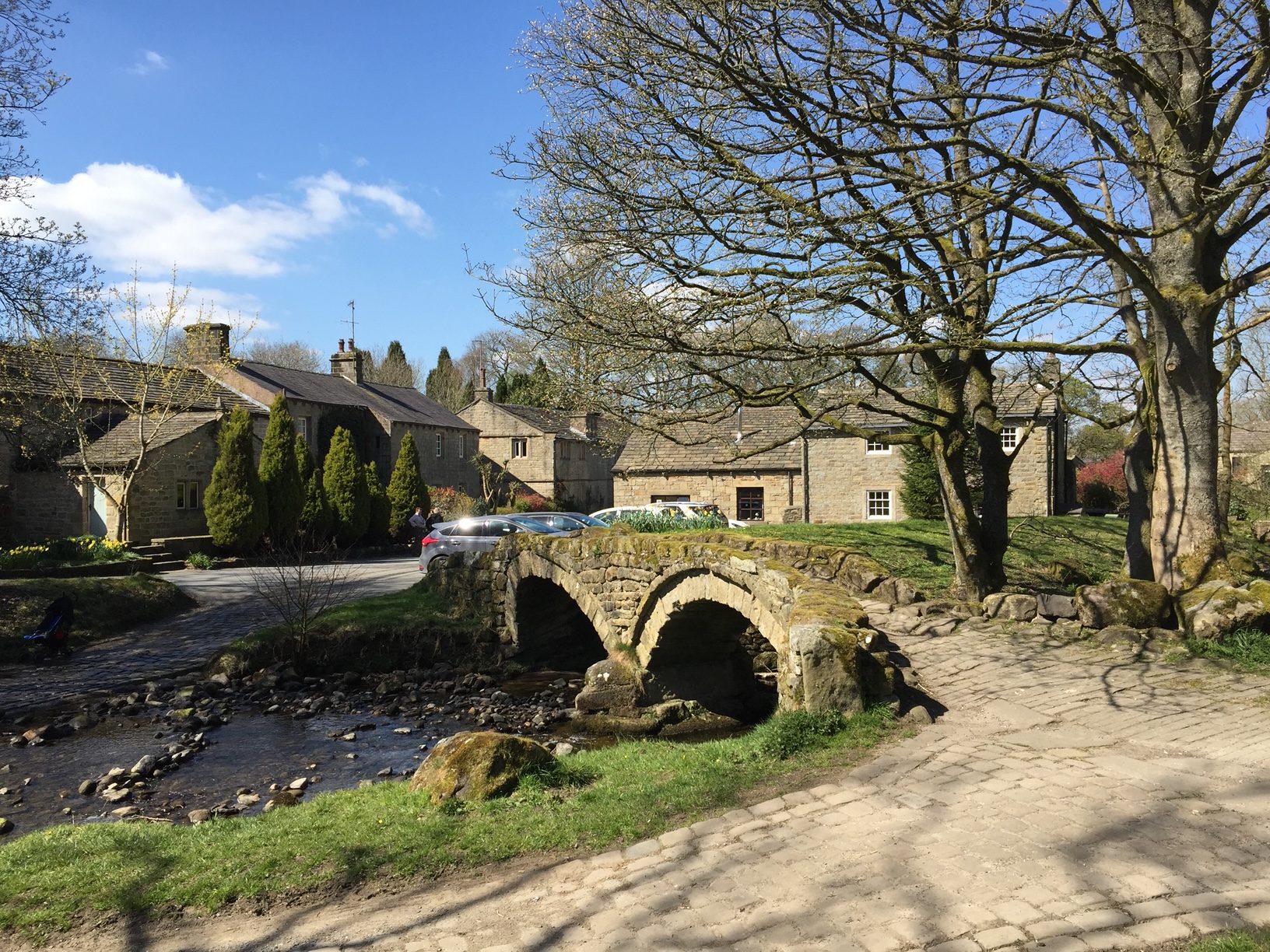
The beautiful village of Wycollar
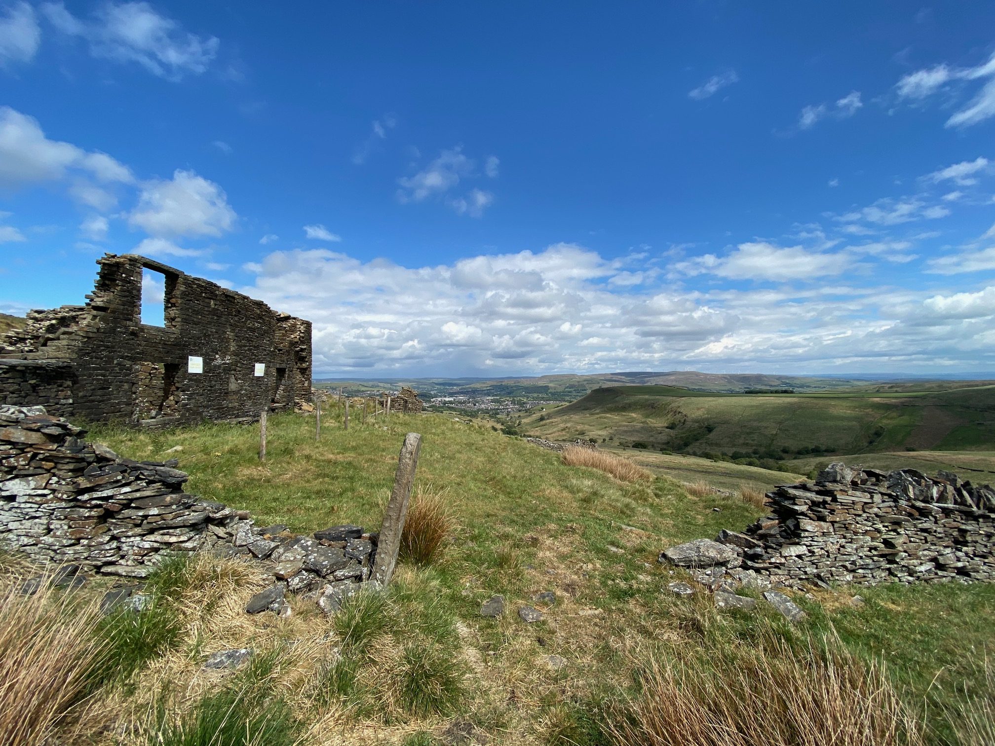
A typical East Lancashire Moorland scene
| LANCASHIRE WAY | ||||||||||
|---|---|---|---|---|---|---|---|---|---|---|
| EASTERN LOOP | ||||||||||
| Stage No | East No | Name | Miles | Hours | Cum Miles | Cum Hrs | Highest Ft | Climb ft | Cum Climb ft | Link |
| 43 | E1 | Burnley to Higham via Padiham | 8.50 | 3.50 | 8.50 | 3.5 | 674 | 779 | 779 | Click Here For Stage 43 |
| 44 | E2 | Barrowford | 5.25 | 2.50 | 13.75 | 6.0 | 937 | 617 | 1,396 | Click Here For Stage 44 |
| 45 | E3 | Barnoldswick | 9.00 | 3.50 | 22.75 | 9.5 | 1297 | 1124 | 2,520 | Click Here For Stage 45 |
| 46 | E4 | Earby | 3.50 | 1.50 | 26.25 | 11.0 | 554 | 296 | 2,816 | Click Here For Stage 46 |
| 47 | E5 | Laneshaw Bridge via Kelbrook | 7.00 | 3.00 | 33.25 | 14.0 | 1127 | 917 | 3,733 | Click Here For Stage 47 |
| 48 | E6 | Thursden | 8.00 | 4.00 | 41.25 | 18.0 | 1689 | 1713 | 5,446 | Click Here For Stage 48 |
| 49 | E7 | Hurstwood | 3.50 | 1.50 | 44.75 | 19.5 | 1267 | 646 | 6,092 | Click Here For Stage 49 |
| 50 | E8 | Cliviger Gorge near Portsmouth | 5.00 | 2.00 | 49.75 | 21.5 | 1173 | 727 | 6,819 | Click Here For Stage 50 |
| 51 | E9 | Whitworth | 7.50 | 3.00 | 57.25 | 24.5 | 1439 | 1054 | 7,873 | Click Here For Stage 51 |
| 52 | E10 | Edenfield/Ramsbottom | 9.75 | 4.00 | 67.00 | 29.0 | 1553 | 1346 | 9,219 | Click Here For Stage 52 |
| 53 | E11 | Edgworth | 8.25 | 3.50 | 75.25 | 33.0 | 1370 | 1068 | 10,287 | Click Here For Stage 53 |
| 54 | E12 | Entwistle Station | 6.00 | 2.50 | 81.25 | 35.5 | 1077 | 929 | 11,216 | Click Here For Stage 54 |
| 55 | E13 | Haslingden Grane | 5.50 | 2.00 | 86.75 | 37.5 | 1241 | 1200 | 12,416 | Click Here For Stage 55 |
| 56 | E14 | Rising Bridge, Accrington | 3.50 | 1.50 | 90.25 | 39.0 | 1064 | 377 | 12,793 | Click Here For Stage 56 |
| 57 | E15 | Loveclough | 3.00 | 1.50 | 93.25 | 40.5 | 1216 | 511 | 13,304 | Click Here For Stage 57 |
| 58 | E16 | Towneley Park, Burnley | 5.75 | 2.50 | 99.00 | 43.0 | 1246 | 578 | 13,882 | Click Here For Stage 58 |
| 59 | E17 | Burnley | 2.25 | 1.00 | 101.25 | 44.0 | 634 | 314 | 14,196 | Click Here For Stage 59 |
If you want a relaxed easy walk then I recommend that you walk the Loop in eight days as follows
Day 1 – Stages E1 and E2 – Burnley to Barrowford, a total of just under 14 miles.
Day 2 – Stages E3, E4 and the first part of E5 to Kelbrook- Barrowford to Kelbrook – 15.5 miles. There are buses north or south or you can stay at the Craven Heifer pub in Kelbrook.
Day 3 – The last part of Stage E5 and then E6and E7 to Hurstwood – 15.5 miles. There is the Hurstwood B&B or you can take a taxi into Burnley were there is lots of suitable accommodation.
Day 4 – Stages E8 and E9 to Whitworth, 12.5 miles. Buses run along the A671 into Rochdale, where you can find accommodation.
Day 5 – Stages E10 to Edenfield, a total of 10 miles. The nearest hotel is the Eagle and Child a short walk south on the A56.
Day 6 – Stages E11 and E12 to Entwistle Station, 14.25 miles. You can catch the train into Bolton for overnight accommodation.
Day 7 – It is possible to complete the walk as it is 20 miles from the end ie Stages E13 to E17. However, this is probably too far for most so split the day into two. You can either stop at the end of Stage E14 in Rising Bridge and take a bus into Accrington or carry on to Loveclough, where you can take a bus into Burnley for overnight accommodation.
Day 8 – The remainder of the Stages which were not completed on day 7.
You can of course complete the walk in four, five or six days, if your legs are up to it. Six days is probably the best as follows.
Day 1 – Stages E1, E2 and the first part of E3- Burnley to Foulridge, a total of 17 miles. Catch a bus back into Burnley for accommodation.
Day 2 – Last part of E3, E4 and E5 to Laneshaw Bridge- 16.5 miles. There are buses back into Burnley for over night accommodation.
Day 3 – Stage E6,E7 and E8 to the Cliviger Gorge – 16.5 miles. Again there is a bus service back into Burnley were there is lots of suitable accommodation.
Day 4 – Stages E9 and E10 to Edenfield, 17.5 miles. The nearest hotel is the Eagle and Child a short walk south on the A56.
Day 5 – Stages E11 and E12 to Entwistle Station, a total of 14.25 miles.
Day 6 – Stages E13 to E17 i.e. to the finish in Burnley – a total of 20 miles.


